

High-accuracy 3D laser scanning and measured building surveys completed in Northern Ireland & Ireland
At Farrimond MacManus, we provide fast, precise surveys of existing buildings using advanced 3D laser scanning technology. Whether you're planning restoration, documentation, or architectural design, our services deliver detailed, accurate data in a fraction of the time required by traditional methods.
028 90387022
3D laser scanning
Our high-definition laser scanning captures full “as-built” 3D data with millimetre accuracy. This method collects up to 50,000 data points per second, creating a detailed point cloud that can be used immediately.
Benefits include:
-
Rapid data collection — complex buildings scanned in days
-
Usable point cloud data available immediately
-
Output available in raw point cloud, 2D/3D CAD, or BIM formats
-
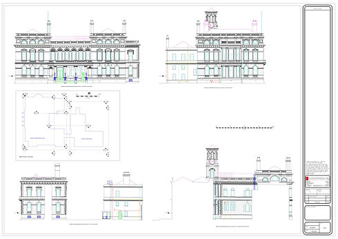
Ideal for producing building elevations, floor plans, and sectional views
This approach is significantly faster and more cost-effective than traditional photogrammetry or manual surveying.
2D measured building surveys
As part of our topographic and historic survey services, we also offer detailed 2D building surveys.
Survey features:
-
Conducted using laser scanning, Total Station, and GPS equipment
-
Scalable from basic floor plans to detailed stone-by-stone elevation drawings
-
Suitable for projects of all sizes and especially valuable for conservation work
We also carry out land surveys.

