
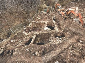
We were recently commissioned to carry out a laser scan survey of the remains of an old mill building which were discovered during ground work excavation for a new water water treatment plant at Aghory, Co Armagh. The mill had a long history dating originally back to the late 18th century when it was a Flax Mill and later a Corn Mill and finally a Saw Mill. While the mill had been demolished several years previously there were no exact records of its construction so a survey of the building layout was required as part of preserving the structure through an accurate measure record and interpretation of its construction. The construction timetable for the development was tight so the most accurate and quickest means of recording the structure was of course through the use of laser scan technology which would allow for the complete 3D capture of the remains of this historic structure.
The scan survey was carried out over a period of 1 working day allowing for minimal machine downtime to achieve the necessary level of recording, something which would traditionally have taken several days with manual measurements and hand drawing. The scan was carried out with a Leica C10 scanner at medium resolution with full colour imagery recorded through the on board camera. Of particular interest was the remains of some of the old machinery which ran from where the water wheel once stood at the north gable end of the building towards the south end of the building.
The scan survey was carried out over a period of 1 working day allowing for minimal machine downtime to achieve the necessary level of recording, something which would traditionally have taken several days with manual measurements and hand drawing. The scan was carried out with a Leica C10 scanner at medium resolution with full colour imagery recorded through the on board camera. Of particular interest was the remains of some of the old machinery which ran from where the water wheel once stood at the north gable end of the building towards the south end of the building.
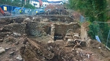
View of mill building and remains of mill machinery
Post processing of the scan data was carried out within Leica Cyclone software and the resultant data was imported into CAD software to produce 2D scale plan, elevation and sectional drawings for inclusion in the archaeological interpretation report.
The scan data was also exported and brought into Autodesk ReCap 360 for collaborative sharing with the project team. ReCap allows the scan data to be presented in a format that doesn't require propriety manufacturers software to share, visualise and interrogate the data. We are particularly excited about the ability to share these types of projects publicly online. Follow the link below and take a tour around this historic mill buildings, where you can even still see some of the mill machinery intact and in place!
https://gallery.autodesk.com/recap360/projects/aghory-mill-laser-scan
 RSS Feed